|
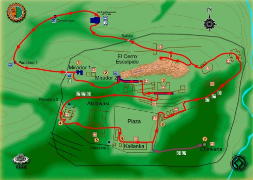
To and Around El Fuerte Samaipata These maps of El Fuerte Samaipata, Bolivia show the route from Santa Cruz to the town of Samaipata and the ancient rock carving itself. Believed to be have been a ceremonial or sacred site, the true origins of these ruins are unknown. Read more about Samaipata and the nearby attractions, including the Samaipata Fort, which is included on all Samaipata tours. Samaipata is also one of the gateways to Amboro National park and one of the stops along the Ruta del Ché (Che Guevara Tour).
https://youtu.be/zxoMIKRwUMg To visit Samaipata, you can take a taxi or bus from the city of Santa Cruz or rent a car and drive on your own. The road to Samaipata is paved all the way. However, as it is a mountain road, it's important to stay informed on weather and road coditions, given that it is prone to rockslides during the rainy season. However you go, be prepared for spectacular views! This map, provided by the state government of Santa Cruz, shows the walking tour path you can take at the Samaipata Fort. Click the map to view a larger version on their website.
Toggle between the map and satellite versions of this map which provides driving directions to Samaipata from Santa Cruz. Use + and - to zoom out. The town of Samaipata is not very large and it's easy to find your way around. Like most cities and towns in Bolivia, everything starts at the central plaza and radiates out from there. Learn more about SamaipataSamaipata tours, sites and attractions In and around the town of Samaipata What to take, know before you go All the ways to get to Samaipata How to drive to Samaipata on your own Road maps and maps of the fort Local tour operators in Samaipata Hotels, hostels and where to stay Samaipata restaurants, cafes and bars Samaipata photo and video gallery View our Samaipata travel forum Return to the Samaipata home page
    |
